Selecting the spatial reference
The spatial reference describes the coordinate system in which the data are referenced and is used to display the trajectories of the plan view.
| |
|

|
To select a spatial reference, a project has to be open.
|
| |
|
|
1.
|
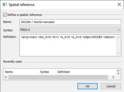
Select  ► Spatial Reference. The following window is displayed: ► Spatial Reference. The following window is displayed: |
|
2.
|
Select a spatial reference among the Recently used list to edit it. |
|
3.
|
Modify the Name of the spatial reference. |
|
4.
|
Select the Syntax in the list. Four syntax to describe a spatial reference are available:
|
|
>
|
EPSG (European Petroleum Survey Group), from Oil and Gas Producers (OGP http://www.epsg.org/)
|
|
>
|
WKT, from Open Geospatial Consortium http://www.opengeospatial.org/standards/ct
|
|
>
|
PROJ.4, from United States Geological Survey (USGS http://trac.osgeo.org), info on PROJ4 syntax: http://proj4.org/operations/projections/index/html
|
|
>
|
ESRI, from ESRI software (http://www.esri.com)
|
|
5.
|
Type the Description of the spatial reference. the details of the geographic and projection systems are accessible from a library file named coordinateSystemLibrary.html. |
This file is available from Start menu > Exail > Delph INS Subsea > online documentation and gives access to the textual information to add the template file inside.
|
6.
|
Click OK to save the modification. |
.

|
The input spatial reference must be WGS84, otherwise the projection on a new frame is not precise. This is the case if the GNSS position itself is expressed in the WGS84 frame. In case of use of the GNSS with an external base, beware to have the differential correction defined in the WGS84 frame to use this functionality.
|